


Planimeter GPS area measure
Description of Planimeter GPS area measure
Planimeter GPS Area Measure
Measure area and distance on the map with the Planimeter app.
* Quickly outline your property or land to calculate distance, perimeter, or area.
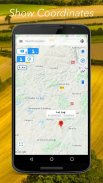
* Find location by address, zip code, or GPS coordinates.
* Find your current location using GPS.
* Drop pins on the map by touch or by GPS coordinates.
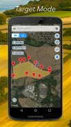
* Target mode for accurate pin placement.
* Full-screen mode.
* Map rotation.
* Delete last/all points with confirmation.
* Map: Satellite, Terrain, and Hybrid modes.
* Convert calculated area and distance into different units (ha, km, miles, etc).
* Drawing mode: for quick landmark outline (Pro, with a subscription).
* Edit mode: for pins adjustment (Pro, with a subscription).
* Settings: adjust workflow (Pro, with a subscription).
* GPS tracking: measure land and property by walking or driving around (Pro, with a subscription).
The planimeter is useful for:
* Field measurements in farming and agriculture
* Property survey for real estate
* Parking, road construction, and fixes
* Farm and land fencing
* Building and construction planning
* Hiking and trip planning
* Landscape design
* Land work estimation and quotes
* Roof or field measurements for solar cell installation
* And many other everyday tasks where land, field, and property measurements are needed
Languages:
English, German, and Russian.
We are constantly working to add new features and improve the app. If you have any feedback or requests, please send us an email at support@vistechprojects.com.
Planimeter GPS area measure - Version 1.0.4
(11-06-2024)Planimeter GPS area measure - APK Information
APK Version: 1.0.4Package: com.vistechprojects.planimeterproLatest Version of Planimeter GPS area measure
Other versions


Apps in the same category

You may also like...
 4.043.784.133.373.992.65


